 Berlstedt.jpg (156240 bytes)
|
The Railfaneurope.net Picture Gallery
Directory: /pix/de/misc/bridge/misc
Last update: Tue Aug 29 22:45:31 CEST 2017
|
|
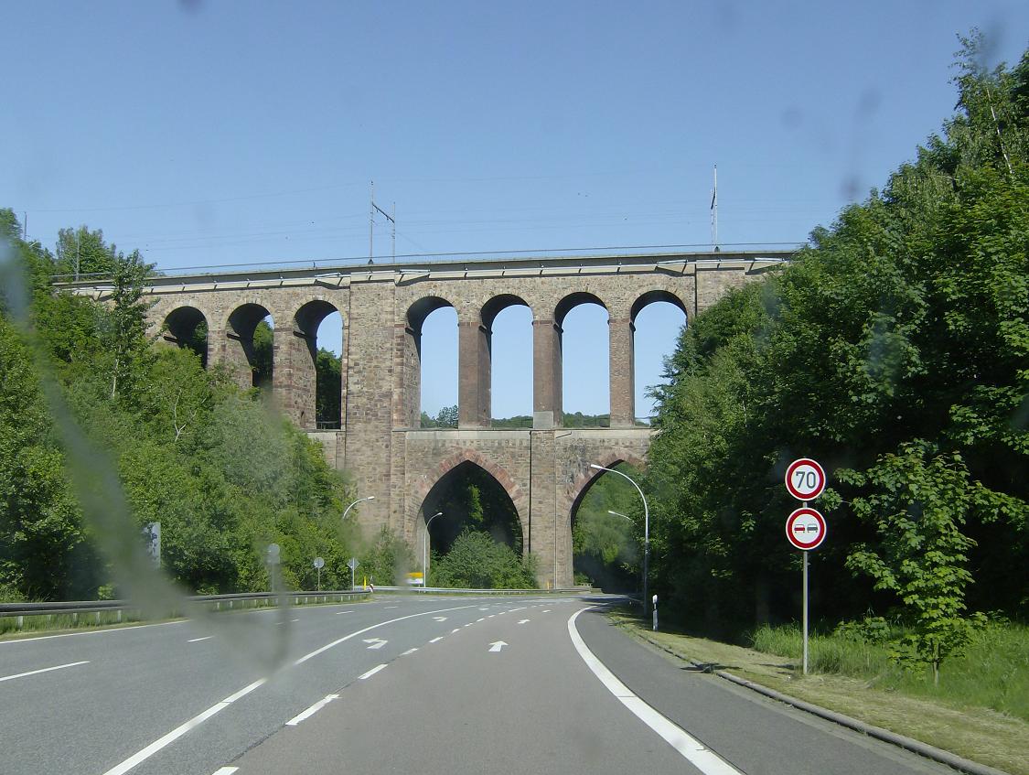
Erfurt¢Leipzig/Halle high-speed railway bridge, Berlstedt Erfurt¢Leipzig/Halle high-speed railway bridge between Berlstedt and Neumark located north-east of Erfurt (route km 210.2 from Ebensfeld). The high-speed line is to be used by a mixture of freight trains and ICEs. Travel time on the line for the 120 km between Erfurt and Leipzig for ICEs is expected to be 39 minutes (compared to about 65 min at present) and between Erfurt and Halle it will be half an hour (about 75 min at present). It is expected to be completed by the end of 2015. Photo taken Monday 22 September 2014. Photo: Steffen Mokosch (Steffen.Mokosch@web.de) |
|
Diedenm³hlenviadukt Diedenm³hle bridge (172 m) near Waldheim bearing the mainline Chemnitz-Riesa. The bridge is located on the so called "Bankrottmeile" (bankruptcy mile), which got this name in the building era of the railway (1848). Sorry for bad quality... photo was shot from car on the federal route 175 Rochlitz-Waldheim-D÷beln. Photo taken Saturday 5 June 2010. Photo: Steffen Mokosch (Steffen.Mokosch@web.de) |
|
This is what remains of the bridge of the railway Pirna - Cotta in
Dohma. The wooden crossties can still be seen on the bridgeheads,
which have otherwise been taken over by trees. The line was in
service from 1894 to 1963. 2001-07-08.
Photo: tobias b k÷hler |
|
Bridge abutments, Dorfchemnitz Bridge abutments of the former Mulda-Sayda narrow gauge line crossing the Chemnitzbach at Dorfchemnitz. Located near the historical iron-headed hammer building of Dorfchemnitz. The narrow gauge rail line Mulda-Sayda was abandoned in 1966 and dismantled until 1969. Photo taken Wednesday 2 March 2011. Photo: Steffen Mokosch (Steffen.Mokosch@web.de) |
|
A Regional Express of the DB crossing the bridge of the Fehmarnsund on August 28th, 2007.
Photo by Patrick Buchholz |
|
Railway bridge across the river Sieg on the eponymous railway line between
Troisdorf and Siegen, situated at the eastern end of Hennef-Blankenberg
station. The line is single track here. 2015-11-22.
Photo by Klaus von der Heyde (asc.soc@freenet.de) |
|
Bridge in Hohnstein (Sõchsische Schweiz), built in 1896 for the narrow
gauge railway Schwarzbachbahn,
which was dismantled in 1951. The bridge still exists and is open for
pedestrians. 2001-06-14.
Photo: tobias b k÷hler |
|
Ilm viaduct, Langewiesen Ilm viaduct of the Nuremberg¢Erfurt high-speed railway near Langewiesen. 1681 m long, it is the longest bridge of the rail line and of the state of Thuringia. Built between 2007 and 2011 but not in use until the opening of traffic in 2017. In addition to the river Ilm the former rail line Ilmenau¢Gro▀breitenbach and the federal route B 88 are spanned. Photo taken Sunday 7 July 2013. Photo: Steffen Mokosch (Steffen.Mokosch@web.de) |
|
Tied-arch bridge, Klingenthal Tied-arch bridge looking like a Schwibbogen candle holder used by Vogtlandbahn trains between Klingenthal in Saxony and Kraslice in the Czech Republic. It is passing federal highway 283. Several metres right there is the Czech border. Photo taken Sunday 28 March 2004. Photo: Steffen Mokosch (Steffen.Mokosch@web.de) |
|
Piesau viaduct, Lichte Piesau viaduct at Lichte carrying the Sonneberg¢Probstzella rail line. With 258 m it is the longest bridge on this line through the Thuringian Highland. Since 1997 the part between Ernstthal am Rennsteig and Probstzella is abandoned so this imposing viaduct is out of use since then. Photo taken Sunday 3 October 2010. Photo: Steffen Mokosch (Steffen.Mokosch@web.de) |
|
Mittweidatal bridge, Markersbach Mittweidatal bridge (86 m) located on a loop of the abandoned rail line Annaberg-Buchholz¢Schwarzenberg at Markersbach. Since 2009 the railway is sometimes used by weekend tourist trains. The new bridge of Federal Route B 101 in the background exemplifies the priorities of actual transport policy. Photo taken Wednesday 13 March 2013, self corrected with Paint Shop. Photo: Steffen Mokosch (Steffen.Mokosch@web.de) |
|
Ostrau railway viaduct Old viaduct of Ostrau (Saxony), carriing the Route from Riesa to Chemnitz. View towards Riesa. The first viaduct from 1847 was destroyed in 1866 by Prussian troops. Photo taken 10 May 2008. Photo: Steffen Mokosch (Steffen.Mokosch@web.de) |
|
Die Eisenbahnbr³cke ³ber der Pegnitz in N³rnberg, auf der Strecke N³rnberg-Neuhaus Pegnitz f³hrt 3 Gleise. 2 f³r den Personenverkehr aus und in Richtung N³rnberg und 1 f³r den G³terverkehr. Diese Br³cke k÷nnte schon ein bisschen Sanirung vertargen.
Foto: Sandor Kovacs E-Mail: SandorKovacs929@hotmail.com |
|
Railway viaduct at Schwarzenhammer Old viaduct of Schwarzenhammer, carriing the former route from Holenbrunn (Marktredwitz) to Selb Stadt abandoned in 1986. The small river bypassed is the Eger which flows from the Fichtelgebirge few kilometers in the west to the Elbe river in the Czech Republic. View towards north. Photo taken on a rainy Sunday 2 May 2010. Photo: Steffen Mokosch (Steffen.Mokosch@web.de) |
|
St. Ingbert/Saar. 2. Viadukt des Industriegleises von Bahnhof zum Kabelwerk St.Ingbert. Juni 2017. Photo by M.Koblischka |
|
St. Ingbert/Saar. 2. Viadukt des Industriegleises von Bahnhof zum Kabelwerk St.Ingbert. Juni 2017. Photo by M.Koblischka |
|
Stone viaduct in the forest near Langenhennersdorf-Waldburg,
seen from the road. This was part of the line Pirna - Bad
Gottleuba, in use from 1880 to 1977. 2001-07-08.
Photo: tobias b k÷hler |
Rheinbruecke zwischen Maxau und Maximiliansau an der Strecke Karlsruhe - WörthEine baufällige Schrägseil-Straßenbrücke (wenn ein Lastwagen vorbeifährt, hüpfen Fußgänger) und eine recht neue Eisenbahnbrücke mit zwei Fachwerk-Überbauten liegen nebeneinander. |
|
Railway bridges in Pirna-Zehista, part of the line from
Pirna to Gro▀cotta. Up to here, the line was operational
until 1999. 2001-07-08.
Photo: tobias b k÷hler |
|
The famous railway viaduct in Zittau, seen from a SOEG train.
Photo (September 2005): Janne Petersson (e-mail: petersson_janne@hotmail.com) |
|
25 Feb 2001, Autobahnkreuz A3-A66, Germany Brücke der Neubaustrecke Köln-Frankfurt über die A66 in unmittelbarer Nähe des Autobahnkreuzes.
Digital photo by Klaus Föhl (kf@ph.ed.ac.uk) |
|
The new bridge crossing the B 264 east of Eschweiler-Weisweiler seen from
the west side on 11 May 2008. It will carry a new line from
Eschweiler-Weisweiler (currently the terminal station of the branch line coming
from Stolberg Hbf via Eschweiler-Talbahnhof) to Langerwehe (located on the
main line Cologne-Aachen). From December 2008 on Euregiobahn services will be
extended to Langerwehe (every train, half-hourly) and even Düren (every
second train, hourly) to enhance the connection towards Cologne.
Digital photo by Christoph Schmitz (christoph.schmitz2@post.rwth-aachen.de) |
|
The bridge crossing the street between Blatzheim and Manheim on the upgraded
line Cologne-Düren
(ABS 4)
seen from the north side on 23 August 2001. The old bridge for two tracks was
extended to carry three tracks. The southern part remained unchanged, this
track will be used for the S-Bahn (urban trains). The northern half of the old
bridge was removed to build a new bridge for the two highspeed tracks. Parts of
the old pillars remained under the new bridge, the old bricks show where they
were. The new pillars will be covered with bricks, too.
Digital photo by Christoph Schmitz |
|
The bridge crossing the street between Blatzheim and Manheim on the upgraded
line Cologne-Düren
(ABS 4)
seen from under it looking towards east on 23 August 2001. The old bridge for
two tracks was extended to carry three tracks. The southern part remained
unchanged, this track will be used for the S-Bahn (urban trains). The northern
half of the old bridge was removed to build a new bridge for the two highspeed
tracks. Parts of the old pillars remained under the new bridge, the old bricks
show where they were. The new pillars will be covered with bricks, too.
Digital photo by Christoph Schmitz |
|
East of Pulheim, a bridge which will lead the new B59n road over the railway
line to Cologne is under construction. On 27 february 2005 (a sunday), a big
crane lifted the five steel girders into position. Obviously for safety reasons
the line was closed for this operation, passengers were transported by busses.
Later the space between the girders will be filled with concrete.
Digital photo by Christoph Schmitz (christoph.schmitz2@post.rwth-aachen.de) |
|
Kleine Br³cke an der stillgelegten Strecke Zeitz - Camburg bei
Utenbach, von 1897 bis 1966 von Z³gen benutzt, heute mit Feldweg. Small bridge at the former line Zeitz - Camburg near Utenbach, used by trains from 1897 to 1966, today with fieldpath.
Photo: Thomas Wedekind, Jena, November 2000 URL: http://www.tom-wedekind.de |
|
Kilometer 121,4 der Main-Weser-Bahn zwischen Lollar und Fronhausen(Lahn); im Bild die Lahnbrücke bei Friedelhausen. Wenige Wochen vor Entstehen dieser Aufnahme wurden die Gleise in Richtung Süden ausgetauscht. Der Abschnitt ist rund sieben Kilometer lang. Datum: 08. April 2002
Digitalfoto von Steffen Hahn. |
|
The street bridge crossing the upgraded line Cologne-Düren
(ABS 4)
near Merzenich seen from east on 23 August 2001. The left part was newly built,
under it the tracks for the S-Bahn (urban trains) are under construction. The
right part is older. It is by now used for the old tracks, in the future the
highspeed tracks will be built there.
Digital photo by Christoph Schmitz |
|
10 September 2000, Mannheim, Germany Old and new railway bridge across the Rhine connecting Mannheim and Ludwigshafen.
Digital photo by Klaus Föhl (kf@ph.ed.ac.uk) |
|
29 Dec 2000, Marbach, Germany Neckarbrücke bei Marbach.
Digital photo by Klaus Föhl (kf@ph.ed.ac.uk) |
|
8 August 2000, Rheinbrücke Waldshut-Koblenz This bridge has recently been refurbished and now even carries an overhead line.
Digital photo by Klaus Föhl (kf@ph.ed.ac.uk) |
|
18 July 2000, Rottenburg, Germany The Horb-Rottenburg-Tübingen line crossing the Rottenburg bypass.
Digital photo by Klaus Föhl (kf@ph.ed.ac.uk) |
|
The SOEG line between Zittau Haltepunkt and Zittau S³d runs under the CD line to Liberec, which actually crosses from Germany into Poland before reaching the Czech Republic. Photographed from train SOE206 on Thursday May 8th, 2003.
Photo by Michael Taylor, Hamilton, Ontario, Canada. (michael@einbahn.org) Website www.EinBahn.org |
|
Konstanz:
An InterRegio train passes the bridge over the Seerhein, the part of
the Bodensee where the Rhine begins, some 100 meters behind Konstanz
station. September 1998.
Sven Herzfeld (herzfeld@maschsee.han.de) |
|
Deutsche Bahn, Güterring Leipzig (cargo ring - a system of railway tracks
surrounding Leipzig which are used by cargo trains only) Temporary line until a new overpass is build for the Güterring near Thekla. The old Güterring brigde crossing the line from Leipzig to Eilenburg can be seen in the background.
Photo by Stephan R. Schilling 2003 |
|
Deutsche Bahn / Halle-Peissen, Germany. Here you see three lines. There is one barely visible behind the bridge. Another line which runs over the bridge has been modernized and renewed for higher speeds. The line in the foreground seems untouched since the end of the GDR.
Photo von/by Stephan R. Schilling Juni/June 2003 |
|
The small tunnel passing under the upgraded line Cologne-Düren
(ABS 4)
east of Königsdorf seen from the south side on 31 July 2002. What looks
very strange is that the southern part has a rounded profile, while the
northern part has a rectangular profile.
Digital photo by Christoph Schmitz |
|
The famous viaduct in Altenbeken (located next to the station on the line
towards Paderborn), seen from the south side on 19 March 2011.
Digital photo by Christoph Schmitz (christoph.schmitz2@post.rwth-aachen.de) |
|
Viadukt ³ber die Wethau an der stillgelegten Strecke Zeitz - Camburg
bei Utenbach, von 1897 bis 1966 von Z³gen benutzt, heute mit Wanderweg. Viaduct over the small river Wethau at the former line Zeitz - Camburg near Utenbach, used by trains from 1897 to 1966, today with footpath.
Photo: Thomas Wedekind, Jena, November 2000 URL: http://www.tom-wedekind.de |
|
22 September 2002, Ludwigshafen, Germany Local train to Mannheim crossing the old Rhine brigde with the new white bridge for the future S-Bahn to the right.
Digital photo by Klaus Föhl (klaus@foehl.net) |
|
Die Großhesseloher Brücke über das Isartal südlich von München mit einem Zug aus oesterreichischen Fahrzeugen Unter den Gleisen befindet sich ein Fußweg The Großhesseloher bridge over the Isar valley south of Munich, with an Austrian train.
Photo by Michael Kauffmann <michael@photo.verm.tu-muenchen.de>
|
 Diedenmu.jpg (161539 bytes)
 Dohma1.jpg (135934 bytes)
 Dorfchemnitz.jpg (158461 bytes)
 Fehmarnsund.jpg (150398 bytes)
 Hohnstein_bruecke.jpg (111157 bytes)
 Ilmtal.jpg (158363 bytes)
 Klingenthalbr.jpg (60163 bytes)
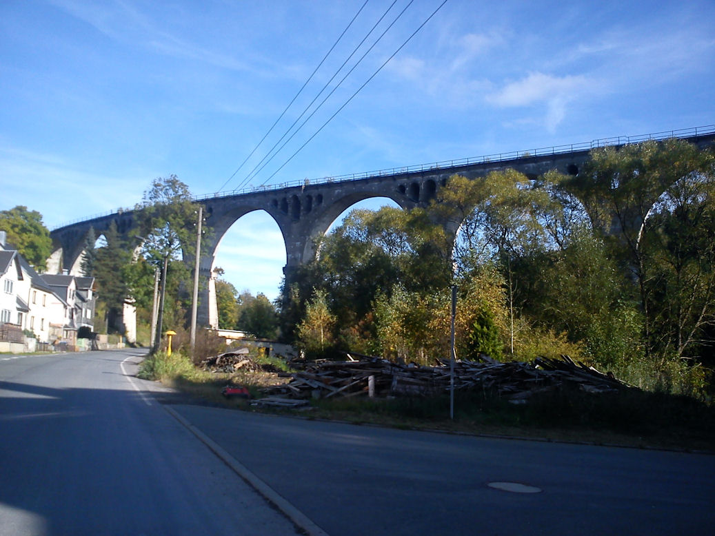 Lichte.jpg (163587 bytes)
 Markersbach.jpg (159413 bytes)
 OstrauB.jpg (59032 bytes)
 Pegnitzbruecke.jpg (115296 bytes)
 Schwarzenhammer.jpg (145297 bytes)
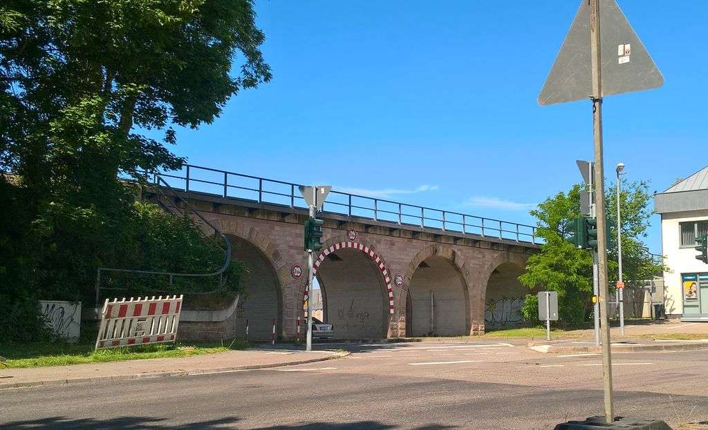 StIngbert_Industriegleis_Viadukt2_1.jpg (155252 bytes)
 StIngbert_Industriegleis_Viadukt2_2.jpg (151221 bytes)
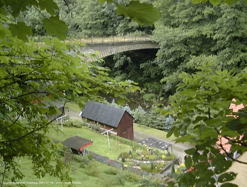 Waldburg1.jpg (149779 bytes)
 Woerth-Bruecke.jpg (38633 bytes)
 Zehista1.jpg (132054 bytes)
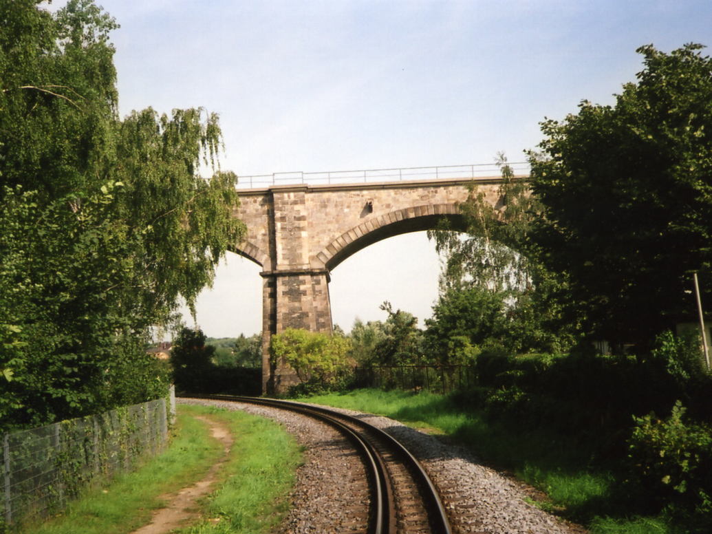 ZittauDB-4.jpg (148006 bytes)
 a3a66kreuz2001_1.jpg (85324 bytes)
 b264we1.jpg (103491 bytes)
 b477_bu1.jpg (103070 bytes)
 b477_bu2.jpg (101446 bytes)
 b59n_pu1.jpg (83097 bytes)
 bruecke_utenbach.jpg (110428 bytes)
 db_main-weser-bahn_2.jpg (97194 bytes)
 k41_me1.jpg (95255 bytes)
 mannheim2000_1.jpg (91353 bytes)
 marbach2000_1.jpg (129330 bytes)
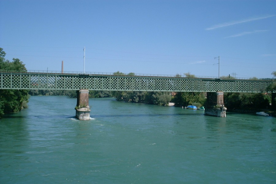 rheinbruecke2000_1.jpg (104467 bytes)
 rottenburg2000_1.jpg (136761 bytes)
 soeg-via-mt.jpg (69252 bytes)
 srh01209.jpg (53202 bytes)
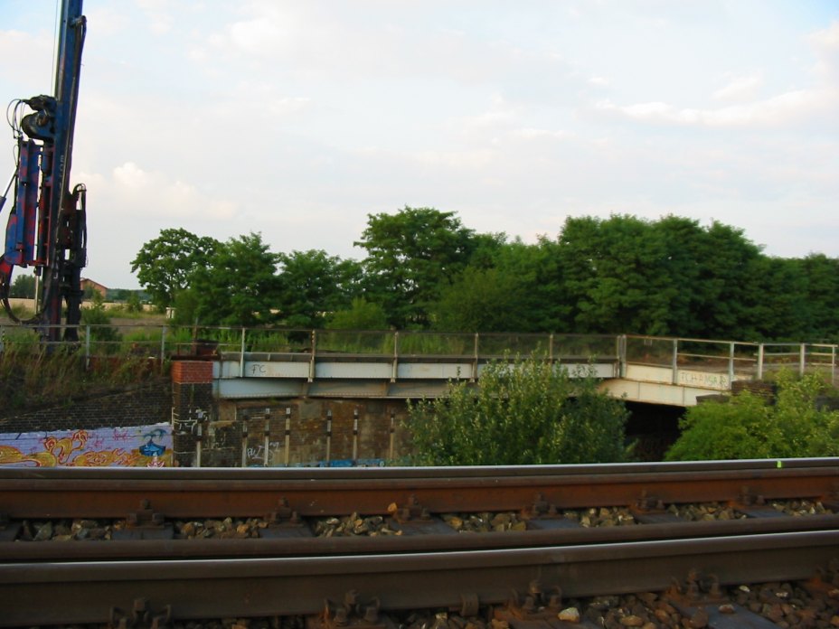 strs_gr_2.jpg (101950 bytes)
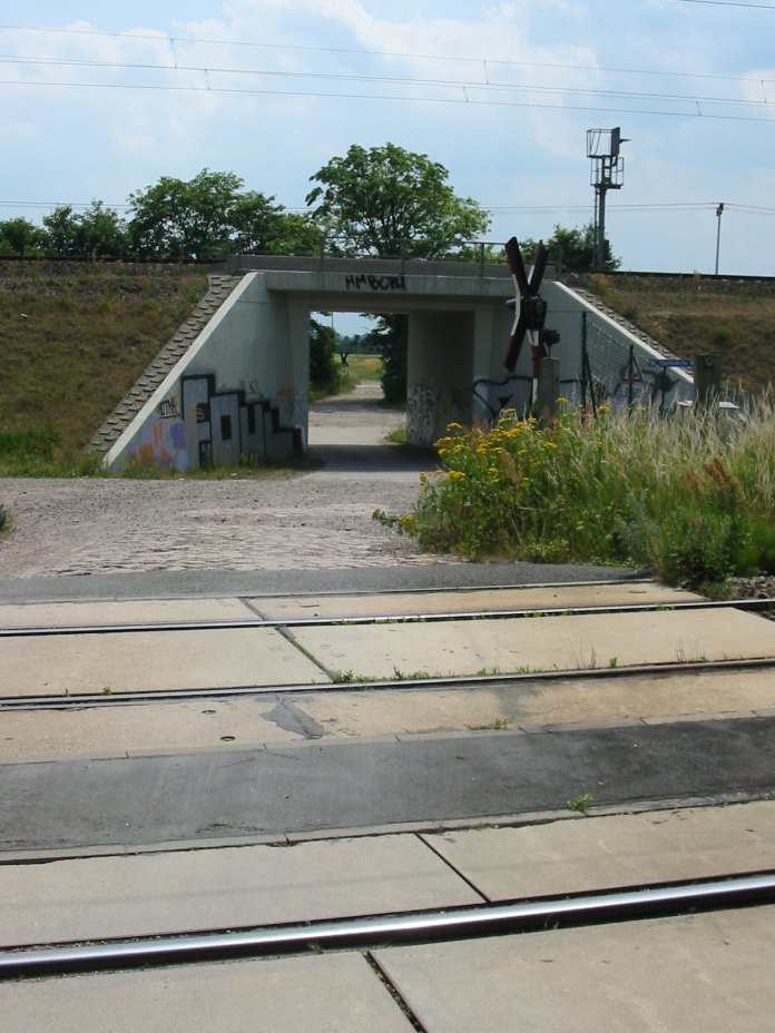 strs_img_0057.jpg (127975 bytes)
 tunnel_ko1.jpg (94490 bytes)
 viaduct_al1.jpg (136808 bytes)
 wethaubruecke_utenbach.jpg (120279 bytes)
 ludwigshafen2002_1.jpg (120393 bytes)
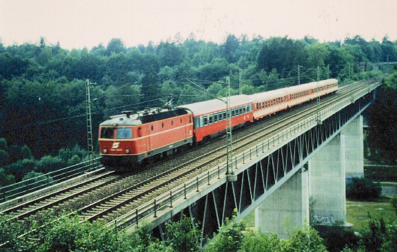 Ghl-Bruecke.jpg (89660 bytes)